Monday May 3, 2010
click here to download today's notes in a more
printer friendly format
Too busy finishing up the grading and preparing the grade
summaries to give much thought to music before today's class.
Time for just one song "Wonderful Tonight" by Eric Clapton (which is, I
think, a beautiful song). I'll try to have something
appropriate for Cinco de Mayo on Wednesday.
Anything turned in by the end of the work day last Friday has been
graded and was returned in class today along with an up-to-date grade
summary. Be sure to check the grade summaries carefully.
The grade summary should say whether you DO or DO NOT have to take
the final exam. Information about the final can be
found on the Final Exam Study Outline.
If
you would like to take the final with the T Th section (Thu., May 13
at 8 am in ILC 140) let me know.
The Course Evaluation was conducted in class today.
This
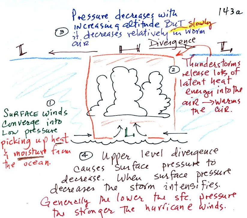
figure tries to explain how a
cluster of thunderstorms can organize and intensify into a hurricane.

1. Converging surface winds pick
up heat and moisture from the ocean. These are the two mains
sources of energy for the hurricane.
2. Rising air expands, cools, and thunderstorm clouds
form. The
release of latent heat during condensation warms the atmosphere.
The core of a hurricane is warmer than the air around it.
3. Pressure decreases more slowly with increasing altitude
in the warm core of the hurricane. The result is that pressure at
the top center of the hurricane is higher than the pressure at the top
edges of the hurricane (pressure at the top center is still lower than
the
pressure at the bottom center of the hurricane). Upper levels
winds diverge and spiral outward
from the top center of the hurricane (you can sometimes see this on
satellite photographs of hurricanes).
4. The upper level divergence will cause the surface
pressure at the center of the hurricane to decrease. The speed of
the converging surface winds increases
and the storm intensifies. The converging winds pick up
additional heat and moisture which warms the core of the hurricane even
more. The upper level high pressure and the upper level
divergence increase. The increased divergence lowers the surface
pressure even more.
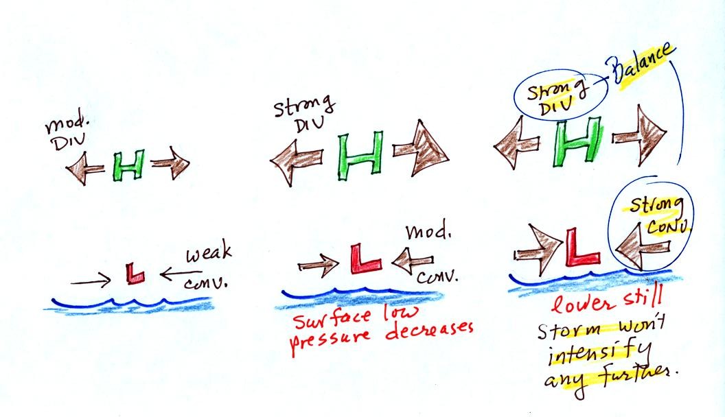
Here's another view of hurricane development and intensification
In the figure at left the upper level
divergence is stronger than the
surface convergence. Divergence is removing more air than is
being added by surface convergence. The surface low pressure will
decrease. The decrease in surface pressure will cause the
converging surface winds to blow faster.
In the middle picture, the surface low pressure is lower, the surface
convergence is stronger. The upper level divergence has also been
strengthened a little bit. The upper level divergence is still
stronger than the surface convergence so the surface so the surface low
pressure will
decrease even more.
In the right figure the surface low pressure has decreased enough that
the surface convergence now balances the upper level divergence.
The storm won't strengthen any more.
Generally speaking the lower the surface pressure at the center of a
hurricane the stronger the storm and the faster the surface winds will
blow. The following figure (not shown in class)
shows
this
This figure tries to show the relationship between surface
pressure and surface wind speed. The world record low
sea level pressure reading, 870 mb, was set
by Typooon Tip off the SE Asia coast in 1979. Sustained winds in
that storm were 190
MPH. Three 2005 Atlantic hurricanes: Wilma, Rita, and Katrina had
pressures in the 880 mb to 900 mb range and winds ranging from 170 to
190 MPH.
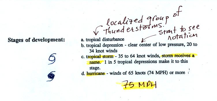
The stages
of storm development that lead up to a hurricane are shown
at the bottom of p. 143a in the photocopied ClassNotes.
A tropical disturbance is just a localized cluster of thunderstorms
that a meterologist might see on a satellite photograph. But this
would merit observation because of the potential for further
development. Signs of rotation would be evidence of organization
and the developing storm would be called a tropical depression.
In order to be called a tropical storm the storm must
organize a little
more, and winds must
increase to 35 knots. The storm receives a name at this
point. Finally when winds exceed 75 MPH (easier to remember than
65 knots or 74 MPH) the storm becomes a hurricane.

A crossectional view of a mature
hurricane (top) and a
picture
like you might
see on a satellite photograph (below).
Sinking air in the very center of a hurricane produces the clear
skies
of the eye, a hurricane's most distinctive feature. The eye is
typically a few 10s of miles across, though it may only be a few miles
across in the strongest hurricanes. Generally speaking the
smaller the eye, the stronger the storm.
A ring of strong thunderstorms, the eye wall, surrounds the
eye.
This is where the hurricane's strongest winds are found.
Additional concentric rings of thunderstorms are found as you move
outward from the center of the hurricane. These are called rain
bands. These usually aren't visible until you get to the outer
edge of the hurricane because they are covered by high altitude layer
clouds.
Hurricanes
are, of course, very destructive.
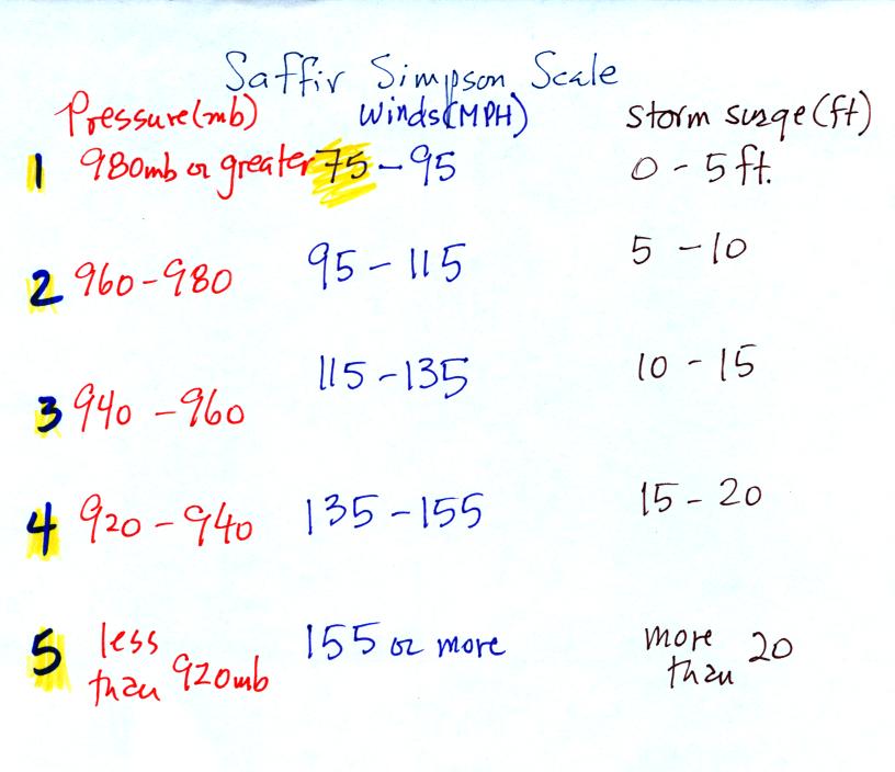
The Saffir-Simpson scale is used to rate hurricane intensity (just
as the Fujita scale is used with tornadoes).
A simplified version of the Saffir-Simpson scale is shown
above.
Pressure decreases by 20 mb, wind speeds increase by 20 MPH, and the
height of the storm surge increases 5 feet for every increase in Saffir
Simpson Scale rating. You don't need to remember all the
numbers. Just remember that there are 5 categories on the scale,
category 1 is the weakest. Hurricane winds must be over 75 MPH
for the storm to be called a hurricane.
A hurricane storm surge is a rise in ocean level caused when
a hurricane moves onshore. It causes most of the destruction
along a coastline. The
following figure shows how a storm surge develops.
Out at sea,
the converging surface
winds
create
surface
currents
in the
ocean that transport water toward the center of the hurricane.
The rise in ocean level is probably only a few feet, though the waves
are much larger. A return flow develops underwater that carries
the water back to where it came from.
As the hurricane approaches shore, the
ocean becomes
shallower.
The return flow must pass through a more restricted space. A rise
in ocean level will increase the underwater pressure and the return
flow will speed up. More pressure and an even faster return flow
is needed as the hurricane gets near the coast. The rise in ocean
level can be more than 20 feet for a category 5 hurricane.
Here is a link to the storm surge website
(from the Hurricane Research Division of the Atlantic Oceanographic and
Meteorological Labororatory). It has an interesting animation
showing output from the SLOSH model used to predict hurricane storm
surges and the flooding they can cause.
And with that we came to
THE END
of what we will be able to cover in
NATS 101 this semester. In class on Wednesday we will begin the
marathon review for Friday's Final Exam.
