Tuesday Mar. 27, 2012
click here to
download today's notes in a more printer friendly format
One full song "Icare" and part
of another "Ibis"
perhaps
from the Cirque du Soleil
presentation of Alegria which I went to see a year or two ago.
The Experiment #3 reports were
collected
today. It usually takes at least 1 week to grade them so you
should expect to get them back sometime next week.
We're getting to the point in this semester where you should already
have completed an experiment report or currently be working on an
experiment. Here's a list of
people that don't seem to have done
that yet. If you're on this list you should get in touch with me
right away.
The Controls of Temperature assignment was also collected today.
Answers to the questions on that assignment will appear online soon.
I handed out what I consider to be a fairly challenging
Optional Assignment. Students were free to turn it in at the
end of class but could also hang onto it, work out the questions over
the weekend, and turn it in at the start of class on Thursday.
You can download the assignment here if your interested in doing the
same.
After class last week I went looking and found a good real world
example of the rain shadow effect in Oregon.
The figure above at left shows the topography of the state (here's
the
source
of that map). Winds generally blow from west to east
across the state.
Coming off the Pacific Ocean the winds first encounter a coastal range
of mountains. On the precipitation map above at right (source)
you
see
a
lot
of
greens and blue on the western sides of the coastal
range. These colors indicate yearly rainfall totals that range
from about 50 to more than 180 inches of rain per year. This is
where temperature rain forests are found.
That's the Willamette River, I think, in between the coastal range and
the Cascades. This valley is somewhat drier than the coast
because air moving off the Pacific has lost some of its moisture moving
over the coastal range.
What moisture does remain in the air is removed as the winds move up
and over the taller Cascades. Yearly rainfall is generally less
than 20 inches per year on the eastern side, the rainshadow side, of
the Cascades. That's not too much more than falls in Tucson which
averages
about 12 inches of rain a year.
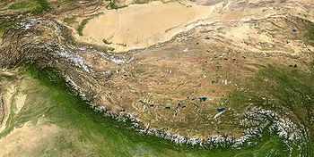
Wikipedia considers the Tibetan Plateau one of the best examples of a
rain shadow.
(here's the source
of the
picture). This example wasn't
shown in class.
The Himalayan mountains stretch across the lower left 1/3 of the
picture. The land below and to the left of the mountains appears
somewhat green in the picture. This is because moist air moving
from lower
left toward the upper right leaves most of its moisture on this side of
the mountain range. The upper right 2/3rds of the picture, the
Tibetan plateau, is in the rain shadow and appears very dry and brown
in the
photograph.
Most of the year the air that arrives in Arizona comes from the west,
from the Pacific
Ocean (this changes in the summer). It
usually isn't very moist by the time it reaches Arizona because it has
travelled up and over the
Sierra Nevada mountains in
California and the Sierra Madre mountains further south in
Mexico. The air loses much of its moisture on the western slopes
of those mountains.
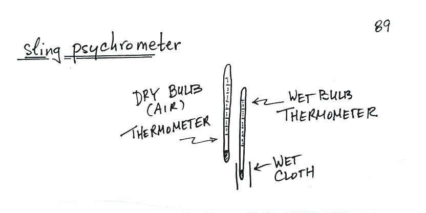
Next in
our mix of topics was measuring
humidity. One of the ways of measuring humidity is to use a sling
(swing might be more descriptive) psychrometer.
A sling
psychrometer consists of two thermometers mounted
side by side. One is an ordinary thermometer, the other is
covered with a wet piece of cloth. To
make a humidity measurement you swing the psychrometer around for a
minute or two and then read the temperatures from the two
thermometers. The difference between the dry and wet bulb
temperatures can be
used to determine relative humidity and dew point (you look up RH and
Td in a table, it's not something you can easily calculate).
You know I like to beat some concepts to death. But also
it's a pretty good example of where you can take some pretty basic
concepts that you understand and use them to really understand
something else.
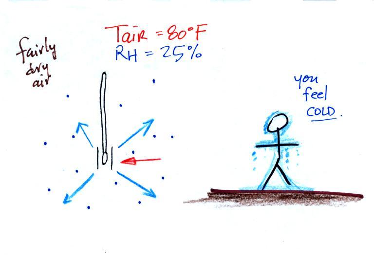
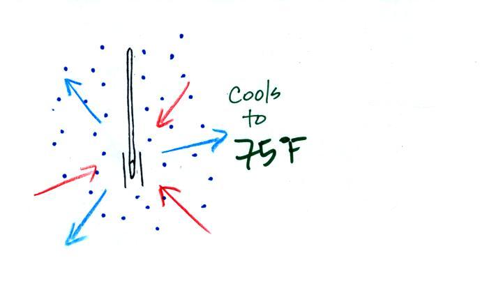
The figure shows what
will happen as you start to swing the wet bulb thermometer. Water
will begin to evaporate from the wet piece of cloth. The
amount
or
rate
of
evaporation
will depend on the water temperature(the
80
F
value
was
just
made
up
in
this
example).
Warm
water
evaporates
at
a higher rate than cool water.
The evaporation is shown as blue arrows because this will cool the
thermometer. The same thing would happen if you were to step out
of a swimming pool on a warm dry day, you would feel cold. Swamp
coolers would work well (too well sometimes) on a day like this.
The figure at upper left also shows one arrow of condensation.
The
amount or rate of condensation
depends on how much water vapor is
in the air surrounding the thermometer. In this case (low
relative humidity) there isn't much water vapor. The
condensation arrow is orange because the condensation will release
latent heat and warm the thermometer.
Because
there is more evaporation (4 arrows) than condensation (1
arrow) the wet bulb thermometer will drop.
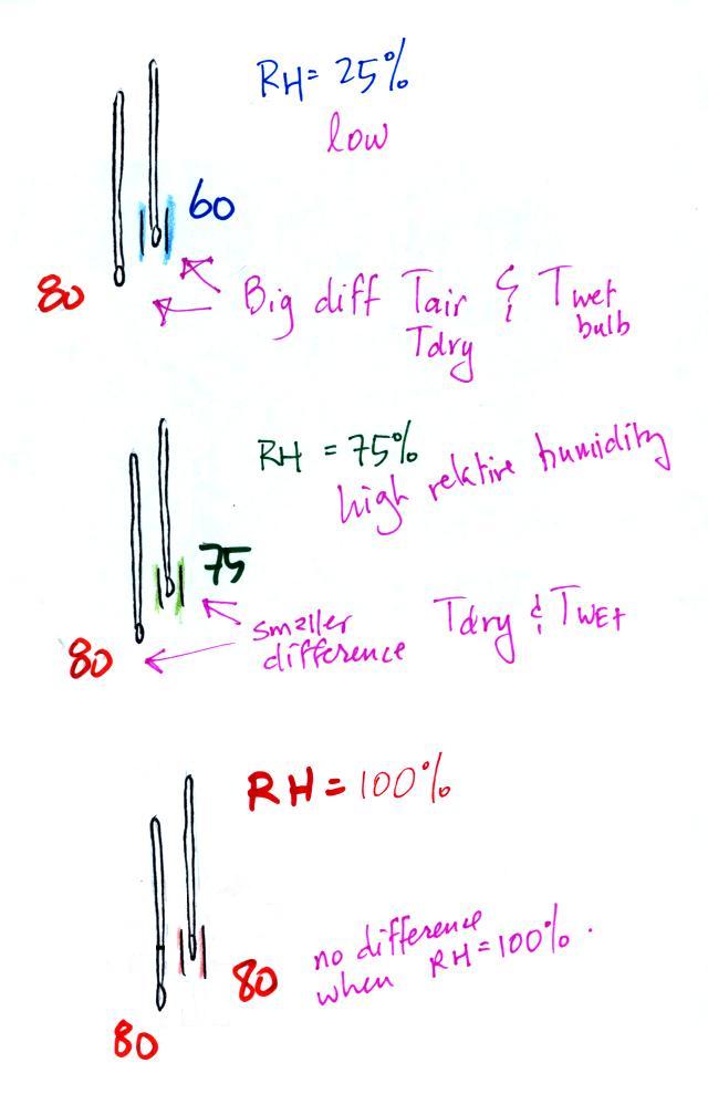
The wet thermometer will cool but it
won't cool indefinitely. We
imagine that the wet bulb thermometer
has cooled to 60 F. Because the wet piece of cloth is cooler,
there is less or slower evaporation. The wet bulb thermometer
has cooled to
a temperature where the evaporation and condensation are in
balance. The thermometer won't cool any further.
You
would measure a large difference (20 F) between the dry and wet bulb
thermometers on a day like this when the air is relatively dry.
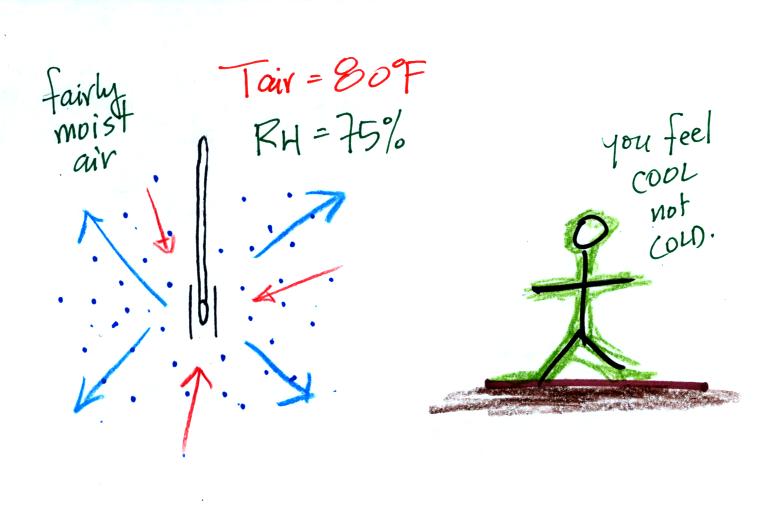
Here's the situation on a
moister day. There's enough moisture in the
air to provide 3 arrows of condensation.You wouldn't feel as cold if you stepped
out of a pool on a warm humid
day like this. Swamp coolers wouldn't provide much cooling on a
day like this.
The wet thermometer only cools a little bit before the rates of
evaporation and condensation are equal.
Here's a summary
A large difference between the dry and wet bulb temperatures
means the relative humidity is low.
A small difference means the RH is higher.
No difference (the bottom figure) means the relative humidity is
100%. Any evaporation from the wet thermometer is balanced by an
equal amount of condensation from the surrounding air.
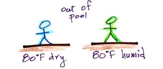
Evaporative
cooling will make you feel cold if
you get
out of a swimming pool on a warm dry day. You won't
feel as cold if the air is humid and the relative humidity is
high. This reminds me of something we covered earlier in the
semester.
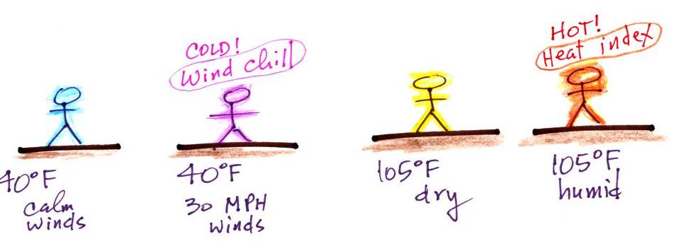
We learned that a
40 F
day with 30 MPH winds will feel colder (because of
increased transport of energy away from your body by convection) than a
40 F
day
with no wind. The wind chill
temperature tells you how much colder it will feel ( a thermometer
would measure the same temperature on both the calm and the windy
day). If your
body isn't able to keep up with the heat loss, you can get hypothermia and
die.
Now something similar but new.
Your body tries to stay cool by perspiring. You
would feel
hot on
a dry 105 F day. You'll feel even hotter on a 105 F day with high
humidity; your sweat won't evaporate
as quickly. The heat index
measures how much hotter you'd feel. The
combination of heat and high humidity is a serious, potentially deadly,
weather hazard
because it can cause heatstroke
(hyperthermia).
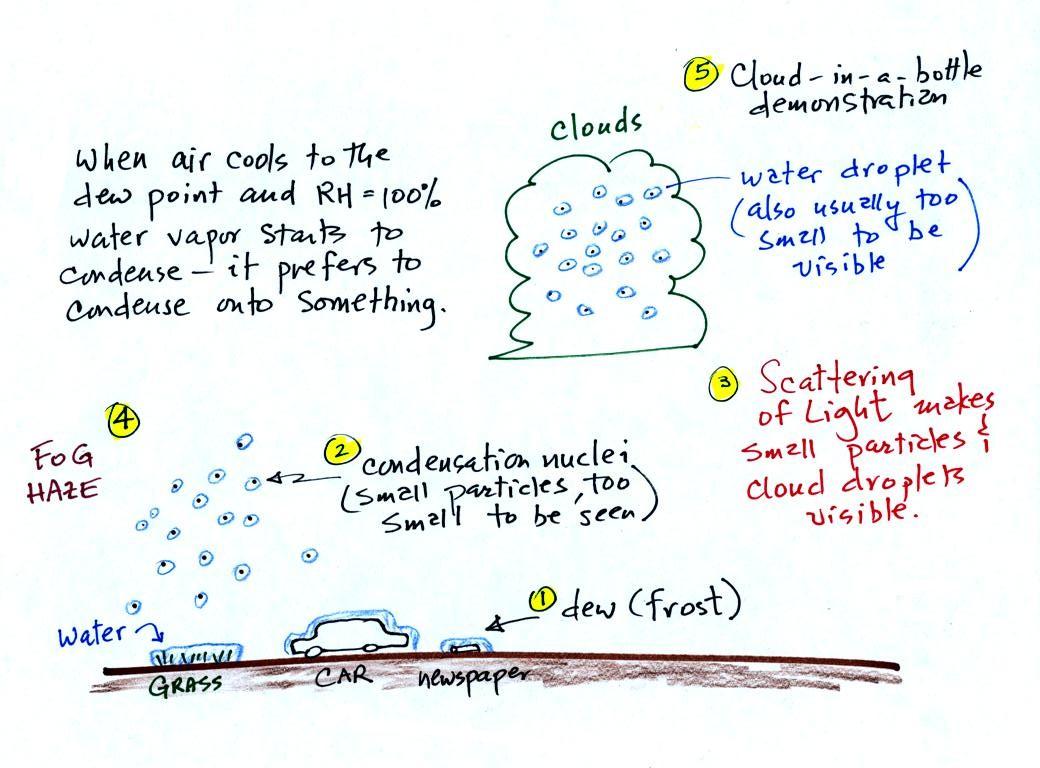
A variety of things can happen when you cool air
to the dew point and
the relative humidity increases to 100%. Point 1
shows that when moist air next to the ground is cooled to
and
below the
dew point, water vapor condenses onto (or is deposited onto) the ground
or objects on the ground. This forms dew, frozen dew, and
frost.
Air above the ground can also be cooled to the dew point. When
that happens (Point 2 above) it is much easier for water vapor to
condense
onto
something rather than just forming a small droplet of pure
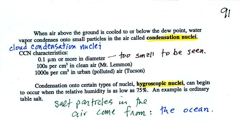
water. In air above the
ground water vapor condenses onto small
particles in the air called condensation nuclei. Both the
condensation nuclei and the small water
droplets that form on them are usually too small to be seen with the
naked eye. We can tell they are present (Point 3) because they
either scatter (haze or fog) or reflect (clouds) sunlight.
It's going to be a busy day, we'll be learning about all of
this before the end of class.
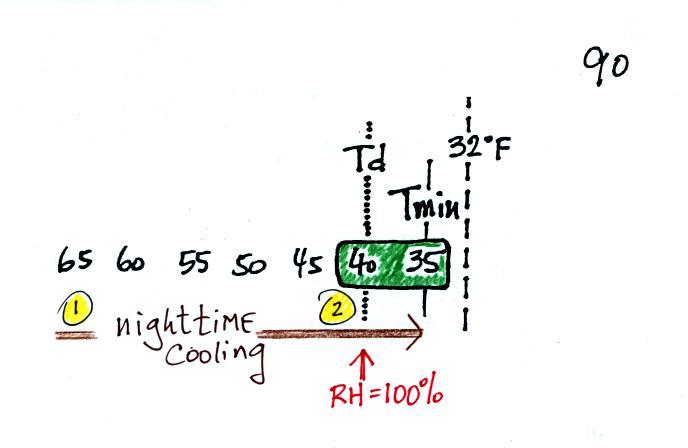
The following confusing figures are found on p. 90 in the photocopied
ClassNotes.
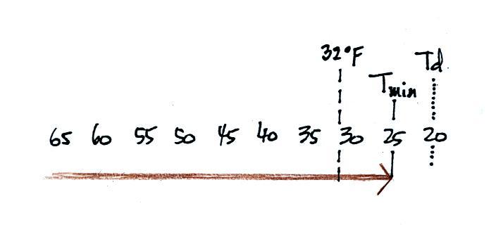
It might be a little hard to figure out what is being
illustrated
here. Point 1 is sometime in the early evening when the
temperature of the air at ground level is 65. During the course
of the coming night the air will cool to 35 F. When the air
temperature reaches 40
F, the dew point, the relative humidity reaches 100% and water vapor
begins to condense
onto the ground. You would find your newspaper
and your car covered with dew (water) the next morning.
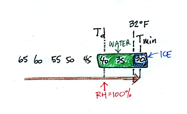
The next night is similar except that the nighttime
minimum
temperature drops below freezing. Dew forms (condensation) and first
covers
everything on the ground with water. Then the water freezes and
turns to ice. This isn't frost, rather
frozen dew. Frozen dew is often thicker and harder to scrape off
your car windshield than frost.
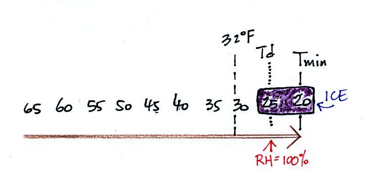
Now the dew point and the nighttime minimum temperature are both
below
freezing. When the RH reaches 100% water vapor turns directly to
ice (deposition).
This
is
frost.
What happens on this night? Because the nighttime minimum
temperature never reaches the dew point and the RH never reaches 100%,
nothing would happen.
I've seen some textbooks refer to this as black frost but I don't like
to use that term. You have probably heard of black ice.
Black ice does sometimes form on road surfaces and is a very dangerous
driving hazard. Because it's hard to see you can hit it with your
car and lose control.
When the
relative humidity in air above the ground (and away from objects on the
ground) reaches 100%, water vapor will condense onto small particles
called condensation nuclei. It would be much harder for the water
vapor to just condense and form small droplets of pure water (you can
learn why that is so by reading the
top
of
p.
92 in the
photocopied class notes). There are always lots of CCN (cloud
condensation nuclei in the air) so this isn't an impediment to cloud
formation.
Water vapor will condense onto
certain kinds of condensation
nuclei
even when the relative humidity is below 100% (again you will find some
explanation of this on the bottom of p. 92).
These
are
called
hygroscopic
nuclei. Salt is an example; small particles of salt
mostly come from evaporating drops of ocean water.
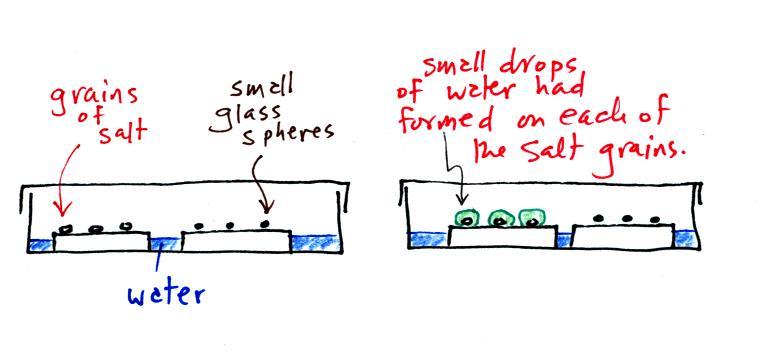
A short homemade video (my first actually) that showed how water
vapor would,
over time,
preferentially
condense onto small grains of salt rather than small spheres of
glass. The
figure
below
wasn't
shown
in
class.
The start of the video at left
showed the small grains
of
salt were
placed on a platform in a petri dish
containing water. Some small spheres of glass were placed in the
same
dish. After about 1 hour small drops of water had formed around
each
of the grains of salt but not the glass grains (shown above at
right).
In
humid parts of the US, water will condense onto the grains of
salt
in a salt shaker causing them to stick together. Grains of rice
apparently absorb moisture which keeps this from happening and also
break up lumps of salt once they start to form. Grains of rice
might also be used because they won't fall out of the holes in the salt
shaker together with the salt. You'll find this discussed in an interesting Wikipedia
article about salt.
The
following figure is at the bottom of p. 91 in the ClassNotes.
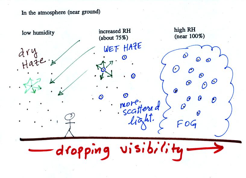
This figure shows
how
cloud
condensation nuclei and increasing relative humidity can affect the
appearance of the sky and the visibility.
The air in the left most figure is relatively dry. Even
though
the condensation nuclei particles are too small to be seen with the
human eye you can tell they are there because they scatter
sunlight. When you look at the sky you see the deep blue color
caused by scattering of sunlight by air molecules mixed together with
some white
sunlight scattered by the condensation nuclei. This changes
the color of the sky from a deep blue to a bluish white
color. The more particles there are the whiter the sky
becomes. This is called "dry haze." Visibility under these
conditions might be a few tens of miles.
The middle picture shows what happens when you drive from the dry
southwestern part of the US into the humid
southeastern US or the Gulf Coast. One of the first things you
would notice is the
hazier
appearance of the air and a decrease in visibility. Because the
relative humidity is high,
water vapor begins to condense onto some of the condensation nuclei
particles (the hygroscopic nuclei) in the air and forms small water
droplets. The water droplets scatter more sunlight than just
small particles alone. The increase in the amount of scattered
light is what gives the air its hazier appearance. This is called "wet
haze." Visibility now might now only be a few miles.
Finally when the relative humidity increases to 100% fog
forms.
Fog can cause a severe drop in the visibility. The thickest fog
forms in dirty air that contains lots of condensation nuclei.
That is part of the reason the Great London Smog of 1952 was so
impressive. Visibility was at times just a few feet! We
could see this effect in the cloud-in-a-bottle demonstration that was
performed next.
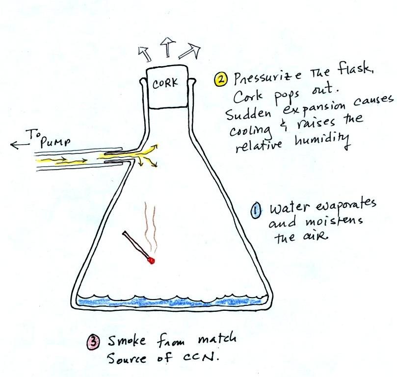
Cooling air, changing relative humidity, condensation
nuclei, and scattering of
light are all involved in this demonstration.
We used my backup flask in class. Normally I use use a
strong, thick-walled, 4 liter vacuum flask (designed to not implode
when all of the air is pumped out
of them, they aren't designed to not explode when pressurized).
There
was a little
water in the bottom of the flask to moisten the air in the flask.
Next we pressurized the air in the flask with a bicycle pump. At
some point the
pressure blows the cork out of the top of the flask.
The air in
the flask expands outward and cools. This sudden cooling
increases the
relative humidity of the moist air in the flask to 100% ( probably more
than 100% momentarily ) and water vapor condenses onto cloud
condensation nuclei in
the air. A very faint cloud became visible at this point.
The demonstration was repeated an
additional time with one
small
change. A burning match was dropped into the
bottle. The smoke from the matches added lots of very small
particles, condensation nuclei, to the air in the flask. The same
amount of water vapor was available for cloud formation but the cloud
that formed
this time was quite a bit "thicker" and much easier to see.
To
be
honest
the burning match probably also added a little water vapor
(water vapor together with carbon dioxide is one of the by products of
combustion).
This effect has some implications for climate change.
A cloud that forms in dirty air is composed of a large
number of small droplets (right figure above). This cloud is more
reflective
than a cloud that forms in clean air, that is composed of a smaller
number of larger
droplets (left figure).
Combustion of fossil fuels adds carbon dioxide to the atmosphere.
There is concern that increasing carbon dioxide concentrations (and
other greenhouse gases) will
enhance the greenhouse effect and cause global warming.
Combustion also adds condensation nuclei to the atmosphere (just like
the burning match added smoke to the air in the flask). More
condensation nuclei might make it easier for clouds to form, might make
the clouds more reflective, and might cause cooling. There is
still quite a bit of uncertainty about how clouds might change and how
this
might affect climate. Remember that clouds are good absorbers of
IR radiation and also emit IR radiation.
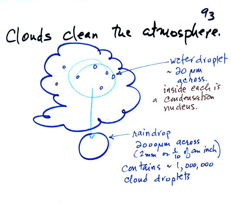
Clouds are
one of
the best ways of cleaning the atmosphere
A cloud is composed of small water droplets (diameters of 10 or 20
micrometers) that form on particles ( diameters of perhaps 0.1 or 0.2
micrometers). The droplets "clump"
together to form a
raindrop (diameters of 1000 or 2000 micrometers which is 1 or 2
millimeters), and the raindrop carries the particles to the
ground.
A typical raindrop can contain 1 million cloud droplets so a single
raindrop
can remove a lot of particles from the air. You may have noticed
how clear the air seems the day after a rainstorm; distant mountains
are crystal clear and the sky has a deep blue color. Gaseous
pollutants can dissolve in the water droplets and be carried to
the ground by rainfall also. We'll be looking at the formation of
precipitation later this week.


