Monday Apr. 14, 2014
I tried out The Soil & the Sun "Like Diamonds"
in the 10 am class. But decided Buena Vista
Social Club "Hasta
Siempre (Che Guevara)" and "Chan Chan"
might be better for the 2 pm people.
The 1S1P reports on Fog have been graded and were returned
today. All but a handful of students received full credit (8
pts). The number in red on your paper is the grade on this
report. The number in green is the total number of points
you have earned so far.
I hope to have the Scientific Paper and Book reports graded by
Wednesday (the ones that were turned in last week anyways).
Part 1 of the Quiz #4 Study Guide is now available even though
Quiz #4 is a little over 2 weeks away. There are several
links on the study guide to help you with the material on Newton's
1st law of motion and the material on surface and upper-level
winds. We will be finishing most of that today. I
think you will find that you are able to figure this material out
without too much trouble or effort. And if you find that you
aren't understanding the material there's plenty of time to remedy
the situation before the quiz.
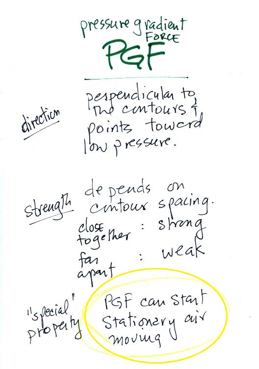
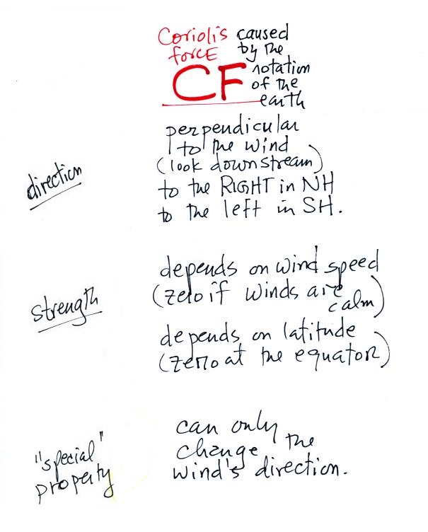
Here's a quick review of the rules for the direction and
strength of the pressure gradient force (PGF) and Coriolis force
(CF)
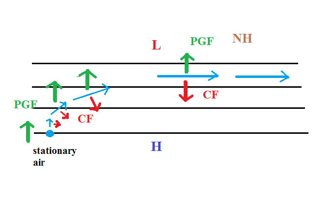
And a quick review of the development of upper level winds in
situations where the contour lines are straight. That's the
simplest kind of situation.
Winds in the northern hemisphere are shown at left. The
picture at right shows the development of winds in the southern
hemisphere. You'll find this explained in more detail at the
end of the Fri., Apr. 11 notes.
Next we'll be looking at the upper level winds that develop
around circular centers of high and low pressure.
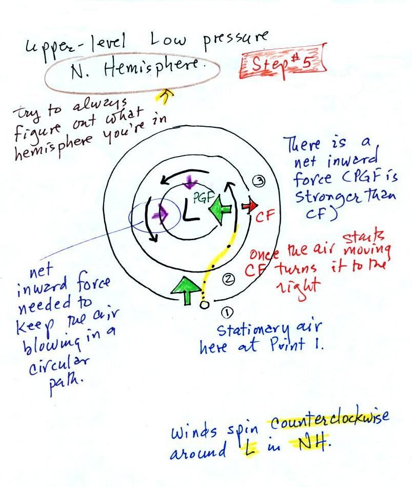
We start with some stationary air at Point 1. Because the
air is stationary, there is no Coriolis force. There is a
PGF force, however. The PGF at Point 1 starts stationary
air moving toward the center of low pressure (just like a rock
would start to roll downhill).
Once the air starts to move, the CF causes it to turn to the
right (because this is a northern hemisphere chart). This
is happening at Point 2 (the dots show the initial motion of the
air). As the wind speeds up the CF strengthens. The
wind eventually ends up at Point 3 blowing parallel to the
contour lines and spinning in a counterclockwise
direction. Note that the inward PGF is stronger than the
outward CF. This results in a net inward force, something
that is needed anytime wind blows in a circular path.
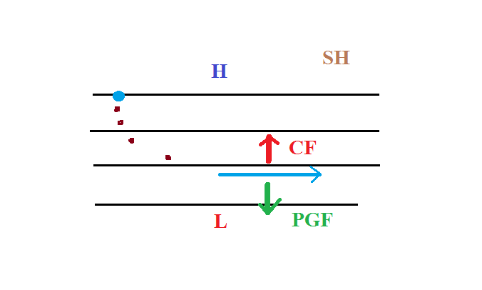
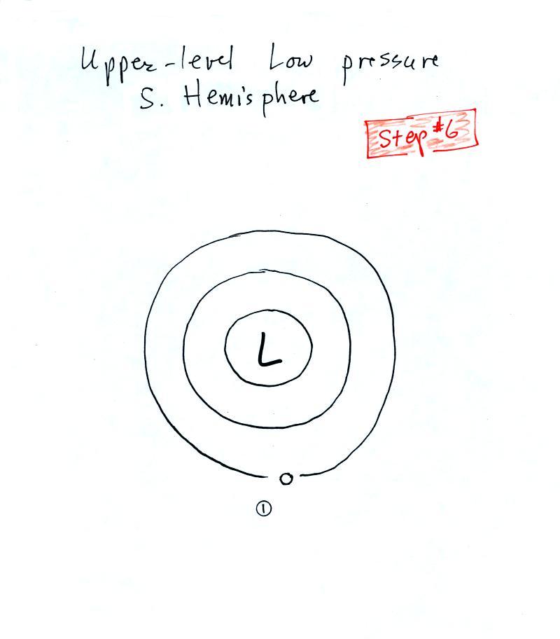
See if you can figure out
what would happen with low pressure in the Southern
Hemisphere.
We start again with some
stationary air at Point 1 in this figure. You'll find the
details at the end of today's notes.
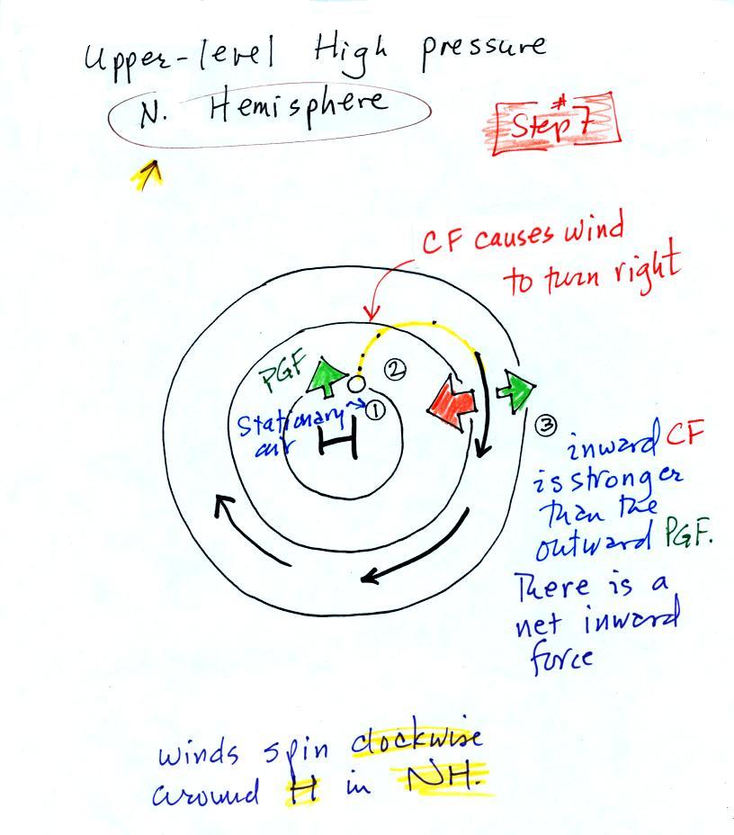
Next we'll look at what happens around
upper level high pressure
Here initially stationary air
at Point 1 begins to move outward in response to an outward
pointing pressure gradient force (PGF). Once the air
starts to move, the Coriolis force (CF) will cause the wind to
turn to the right. The wind ends up blowing in a
clockwise direction around the high. The inward pointing
CF is a little stronger than the PGF so there is a net inward
force here just as there was with the two previous examples
involving low pressure. An inward force is need with
high pressure centers as well as with centers of low
pressure. An inward force is needed anytime something
moves in a circular path.
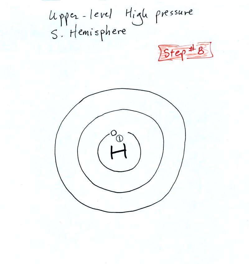
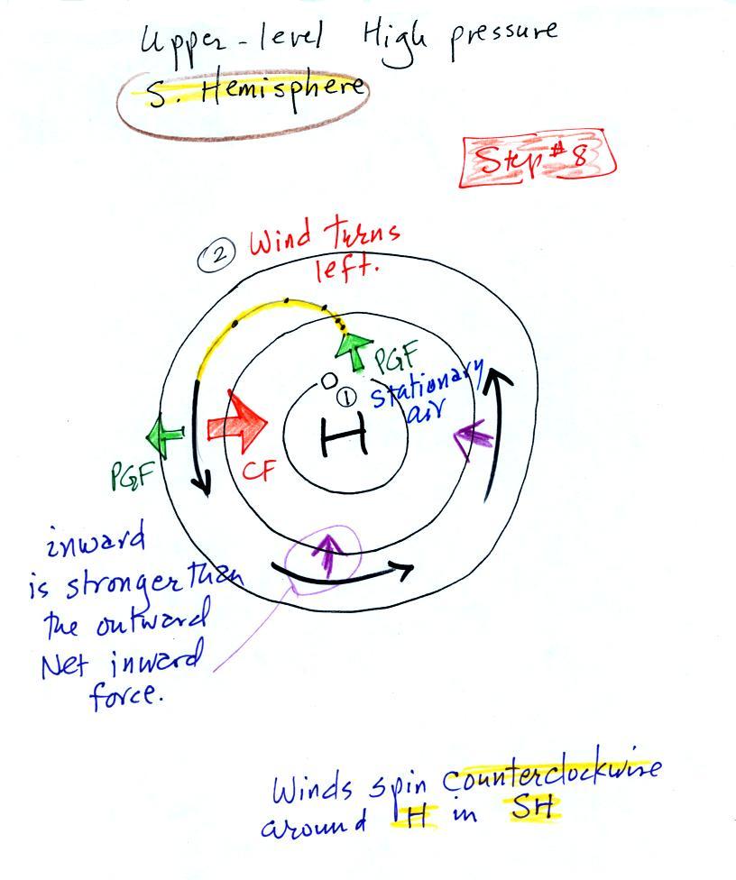
This is a southern hemisphere upper level center of high
pressure. You should be able to figure out how the winds
will blow in this case. You'll find the
answer at the end of today's notes.
Upper level winds blow parallel to the contour lines.
Next we'll try to understand why friction causes surface winds
to blow across the contour lines (always toward low pressure).
With surface winds we need to take into account the PGF, the
CF, and the frictional force (F). That means
we'll need some rules for the direction and strength of the
frictional force. Friction arises with surface winds
because the air is blowing across (rubbing against) the
earth's surface.

The strength of the frictional force depends on speed.
The faster you try to go the harder it becomes because of
increased wind resistance. It's harder to ride on a
rough road than on a smooth road surface. In the case of
air there is less friction when wind blows over the ocean than
when the air blows over land. If the wind isn't blowing
there isn't any friction.
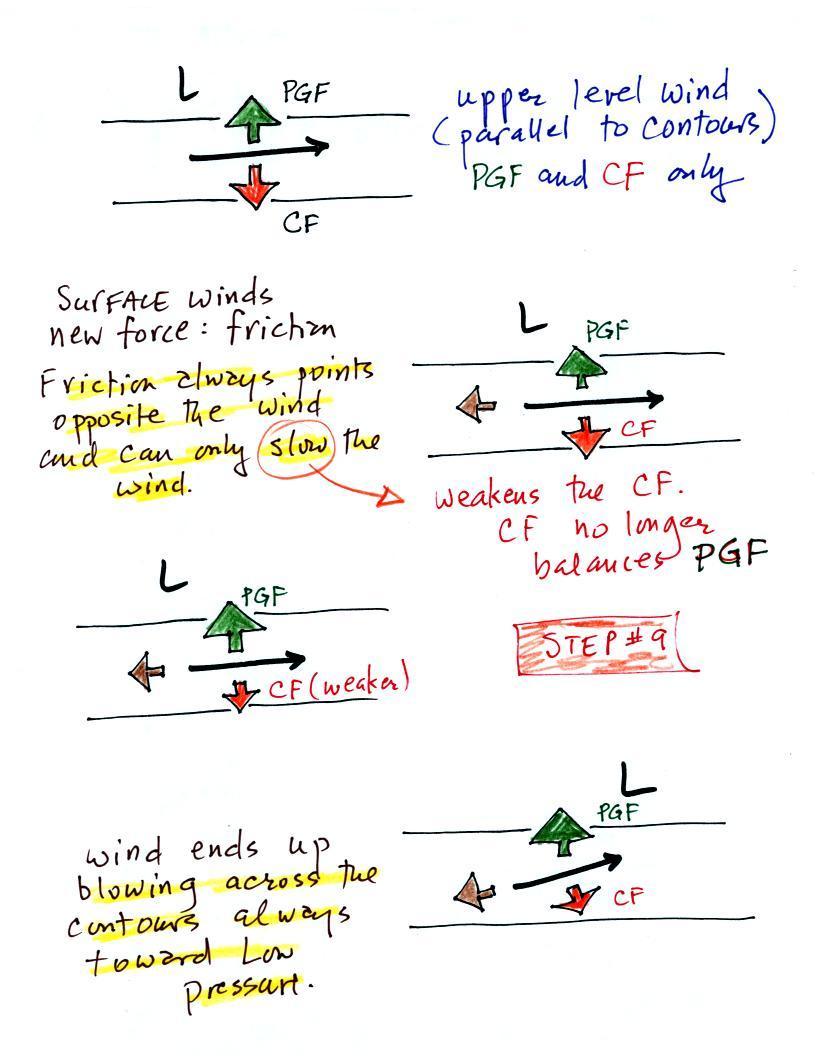
We add friction in the second picture. It points in a
direction opposite the wind and acts to slow the wind
down.
Slowing the wind weakens the CF and it can no longer balance
the PGF (3rd figure). The stronger PGF causes the wind
to turn and start to blow across the contours toward
Low. This is shown in the 4th figure.
One of the key things to remember is that friction causes
surface winds to blow across the contours always toward low
pressure.
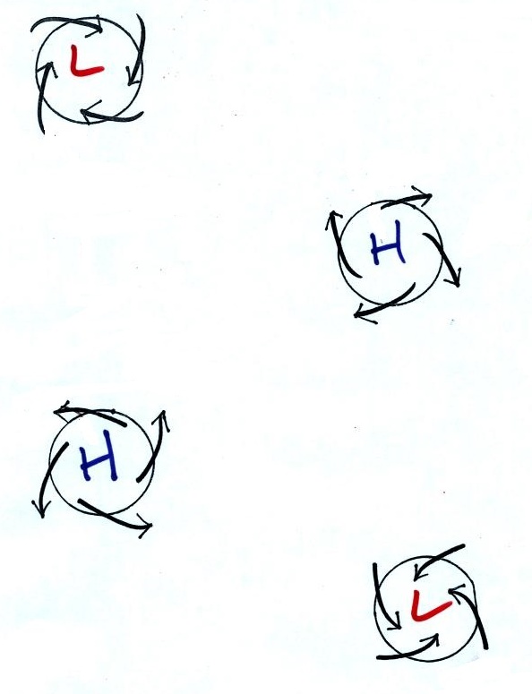
It should be very easy to figure out which two of the figures
above are surface centers of low and high pressure.
Winds blow into the centers of low pressure and
outward away from centers of high pressure.
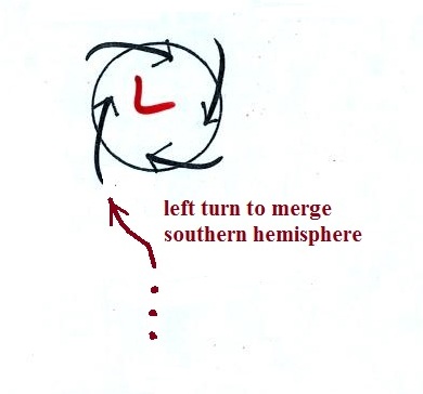
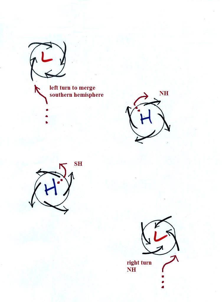
Next to determine whether each figure is in the northern or
southern hemisphere we will imagine approaching the upper left
figure in an automobile. And instead of winds, the
arrows represent other cars driving around a traffic circle.
What direction would you need to turn in order to merge
with the other cars. In this case it's left. That
left turn tells you this is a southern hemisphere map.
The remaining examples are shown below
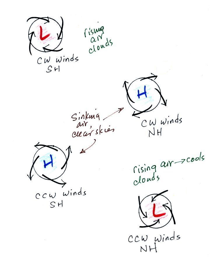
Converging winds cause air to rise. Rising air expands
and cools and can cause clouds to form. Clouds and
stormy weather are associated with surface low pressure in
both hemispheres. Diverging winds created sinking wind
motions and result in clear skies.
Somethings change when you move form the northern to the
southern hemisphere (direction of the spinning winds).
Sometimes stay the same (winds spiral inward around centers of
low pressure in both hemispheres, rising air motions are found
with centers of low pressure in both hemispheres).
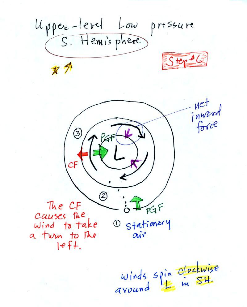
Here are the two figures showing
how the figure showing how upper level winds
blow around Low pressure in the Southern
Hemisphere.
The stationary air starts to move in toward the
center of low pressure (just like it did in the
northern hemisphere). But then it takes a
left hand turn rather than a right hand
turn. This is because the CF is
perpendicular and to the left of the wind (as you
look downstream) in the southern hemisphere.
The wind ends up spinning clockwise around L in
the southern hemisphere.
Winds that blow around high pressure in the
southern hemisphere. The air starts to move
outward but then turns left due to the Coriolis
force. The result is that winds spin
counterclockwise around H in the southern
hemisphere.