Friday Sept. 19, 2008
Click here
for a more printer friendly version of these notes in Microsoft WORD
format.
Caution the notes were put
together in a little bit of a hurry Friday afternoon, watch for typos.
The 1-2 pm class before us was finishing up an exam so we only had time
for one song "Two Silver Trees" from Calexico. It is
a little quieter than some of the other songs we heard this week and is
from their 2008 CD Carried
to Dust.
The Expt. #1 reports are due next
Monday. If you haven't brought in your materials, please do so on
Monday with your report. The graduated cylinders are needed for
Expt. #2. Expt. #2 materials will
hopefully be available in class on Wednesday next week before the quiz.
The newly added Tuesday afternoon 2-3 pm review will be held in Modern
Languages 310 next week. The usual 4-5 pm reviews will still be
held Monday and Tuesday afternoons in FCS 225.
Optional Assignment #1
is due at the beginning of class on Monday. Answers will be
posted online since you won't get your papers back before the quiz.
Hey! Look
carefully
through today's online notes - there's a hidden optional
assignment. If you decide to do the assignment it's due at the
beginning of class on Monday.
Class started with a quick review of the station model notation used to
plot weather data on a surface weather map.
We haven't learned how to decode the pressure data yet.
Meteorologists hope to map out small horizontal pressure
changes on
surface weather maps (that produce wind and storms). Pressure
changes much more quickly when
moving in a vertical direction. The pressure measurements are all
corrected to sea level altitude to remove the effects of
altitude. If this were not done large differences in pressure at
different cities at different altitudes would completely hide the
smaller horizontal changes.
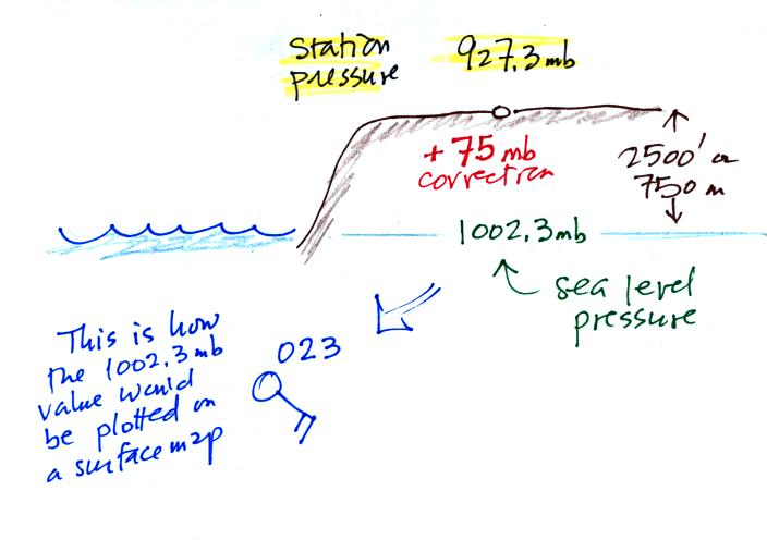
In the example above, a station
pressure value of 927.3 mb was measured in Tucson. Since Tucson
is about 750 meters above sea level, a 75 mb correction is added to the
station pressure (1 mb for every 10 meters of altitude). The sea
level pressure estimate for Tucson is 927.3 + 75 = 1002.3 mb.
This is also shown on the figure below
Here's the remainder of p. 37 in
the photocopied ClassNotes.

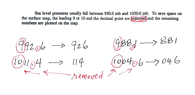
To save room, the leading 9 or 10 on the sea level pressure
value and
the decimal
point are removed before plotting the data on the map. For
example the 9 and the . in
992.6 mb would
be removed; 926
would be plotted on the weather map (to the upper right of the center
circle). Some additional examples are shown above.
When reading pressure values off a
map you must remember to
add a 9 or
10 and a decimal point. For example
163 could be either 916.3 or 1016.3 mb. You pick the value that
falls between 950.0 mb and 1050.0 mb (so 1016.3 mb would be the correct
value, 916.3 mb would be too low).
Another
important piece of information that is included on a surface weather
map is the time the observations were collected. Time on a
surface map is converted to a universally agreed upon time zone called
Universal Time (or Greenwich Mean Time, or Zulu time).
That is the time at 0 degrees longitude. There is a 7 hour time
zone difference between Tucson (Tucson stays on Mountain
Standard Time year round) and Universal Time. You must add 7
hours to the time in Tucson to obtain Universal Time.
Here are some examples (only
the first example was worked in class):
2:15 pm MST:
first convert 2:15 pm to the 24
hour clock format 2:15 + 12:00 = 14:15 MST
then add the 7 hour time zone correction ---> 14:15
+ 7:00 = 21:15 UT (9:15 pm in Greenwich)
9:05 am MST:
add the 7 hour time zone
correction ---> 9:05 + 7:00 = 16:05 UT (4:05 pm in England)
18Z:
subtract the 7 hour time zone
correction ---> 18:00 - 7:00 = 11:00 am MST
02Z
if we subtract the 7 hour time zone correction we will get a negative
number. We will add 24:00 to 02:00 UT then subtract 7 hours
02:00 + 24:00 = 26:00
26:00 - 7:00 = 19:00 MST on the previous day
2 hours past midnight in Greenwich is 7 pm the previous day in
Tucson
A bunch of weather data has been plotted on a map in
the figure
below.
Plotting the surface weather
data
on a map is
just the
beginning.
For example you really can't tell what is causing the cloudy weather
with rain (the dot symbols are rain) and drizzle (the comma symbols) in
the NE portion of the map above or the rain
shower along the Gulf Coast. Some additional
analysis is needed. A meteorologist would usually begin by
drawing some contour lines of pressure to map out the large scale
pressure pattern. We will look first at contour lines of
temperature, they are a little easier to understand.
I told you I would finish coloring
the map when I got back to my office. Isotherms, temperature
contour lines, are usually drawn at 10 F
intervals.
They do two things: (1) connect points on the map that all
have the same temperature, and (2) separate regions that are warmer
than a particular temperature from regions that are colder. The
40o F isotherm highlighted in yellow above passes through
a city which is reporting a temperature of exactly 40o.
Mostly it goes
between pairs of
cities: one with a temperature warmer than 40o and the other
colder
than 40o. Temperatures
generally decrease with
increasing
latitude.

Now the same data with isobars
drawn in. Again they
separate
regions with pressure higher than a particular value from regions with
pressures lower than that value.
Isobars are generally drawn at 4 mb intervals. Isobars also connect points on the map
with the same pressure. The 1008 mb isobar (highlighted in
yellow) passes through a city where the pressure is exactly
1008.0 mb. Most of the time the isobar
will pass between two
cities. The 1008 mb isobar passes between cities with
pressures
of 1009.1 mb and 1004.7 mb (if you look hard you'll find them).
You would
expect to find 1008 mb somewhere in between
those two cites, that is where the 1008 mb isobar goes.
The pattern on this map is very different from the
pattern
of
isotherms. On this map the main features are the circular low and
high pressure centers.
I promised you some kind of a
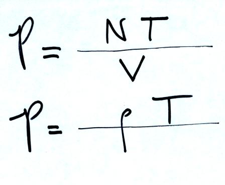
demonstration showing how air temperature affects pressure. Here
are the two ideal gas law
equations again (without the constants k and R). Here also is the
hidden optional assignment.

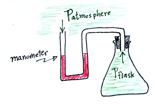
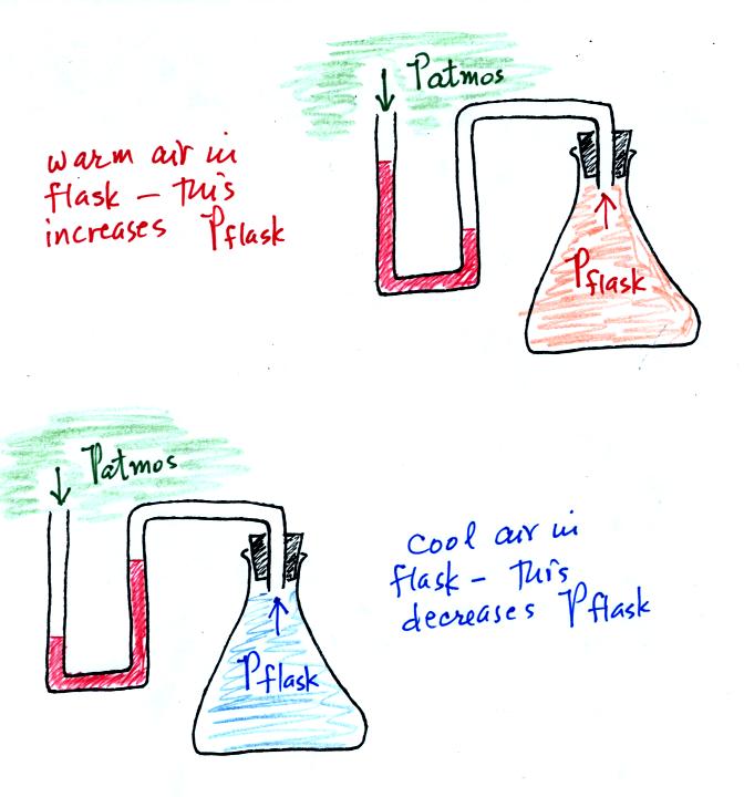
We used a
flask connected to a manometer. A
manometer is able to detect differences in pressure (differences
between the pressure of the air inside the flask compared to the air
outside the flask)
Initially the air in the flask was exactly
the same as the air
outside. The levels of the red liquid in the manometer were the
same indicating the Patmosphere and Pflask were
the same. Next we both warmed (warm hands) and cooled (liquid
nitrogen) the air in the
flask.
Warming the air in the flask increased the
pressure inside the
flask. Cooling the flask reduced the pressure of the air in the
flask. The changing liquid levels revealed these changes in
pressure.
You can really start to say alot about the weather once you have mapped
out the pressure pattern. Differences in pressure create a force
that causes the wind to blow. Wind motions then can lead to
stormy or fair weather.
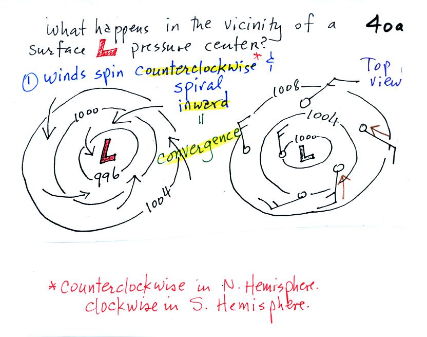
Air will start moving
toward low
pressure (like a rock sitting on a hillside that starts to roll
downhill), then something called the Coriolis force will cause
the
wind to start to spin (we'll learn more about the Coriolis force later
in the semester). Winds spin in a counterclockwise (CCW) direction
around surface
low pressure
centers. The winds also spiral inward toward the center of the
low, this is called convergence. [winds spin clockwise around low
pressure centers in the southern hemisphere but still spiral inward]
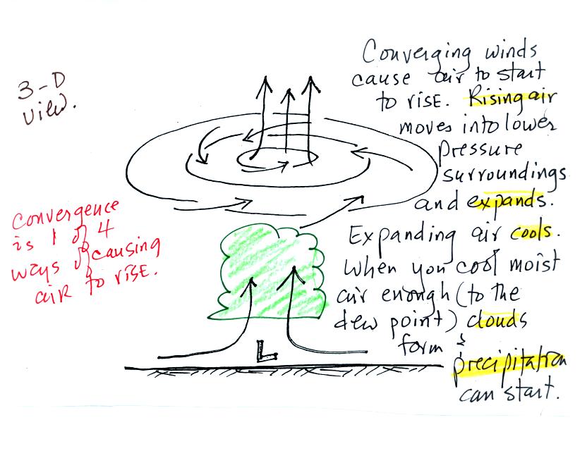
hen the converging air reaches the
center of the low, the starts to rise.
Rising air expands and cools. If the air is sufficiently moist
clouds can form and then begin to rain or snow. Thus you often
see
cloudy skies and stormy weather associated with surface low pressure.
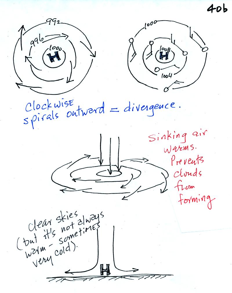
Surface high pressure
centers are pretty much just the opposite situation.
Winds spin clockwise
(counterclockwise in the southern hemisphere) and spiral outward.
The
outward motion is called divergence.
Air sinks in the center of
surface high pressure to
replace the diverging air. The sinking air is compressed and
warms. This keeps clouds from forming so clear
skies are normally found with high pressure (clear skies but not
necessarily warm weather, strong surface high pressure often forms when
the air is very cold).
A good productive class today in NATS 101 - have a nice weekend.


